By Matt Marcus
In March 1997, the West Virginia Division of Highways (WVDOH) and the engineering firm Michael Baker International came out with a “final design” for the Elkins to the Virginia State Line sections of Corridor H. Although this was intended to be a final alignment, since 1997, there have been major economic and traffic pattern changes in Tucker County and changes to the Corridor H highway alignment itself.
For example, instead of the highway going through Hambleton, Parsons, Corrick’s Ford, crossing the Black Fork River and going up the Shavers Fork River Valley, Corridor H was rerouted downstream across Holly Meadows and the Cheat River north of Parsons.
This section between Kerens and Parsons is currently being constructed and it involves an entirely different route from the original. Changes and improvements to the highway design resulted in rerouting over 15 miles of highway. Major design changes to Corridor H construction in Tucker County have already been employed to avoid sensitive and historic areas.
What is going on now
Tucker County residents, visitors and businesses are now calling for changes to the old design of the Parsons to Davis section of Corridor H. The alignment now being considered as an alternative to the old plan is called the Blackwater Avoidance Alternative 2 (BAA2). BAA2 is often referred to as the Northern Route because it loops north of Thomas, negating the need for a Thomas bypass.
What’s wrong with the DOH’s preferred route (R-ROPA)
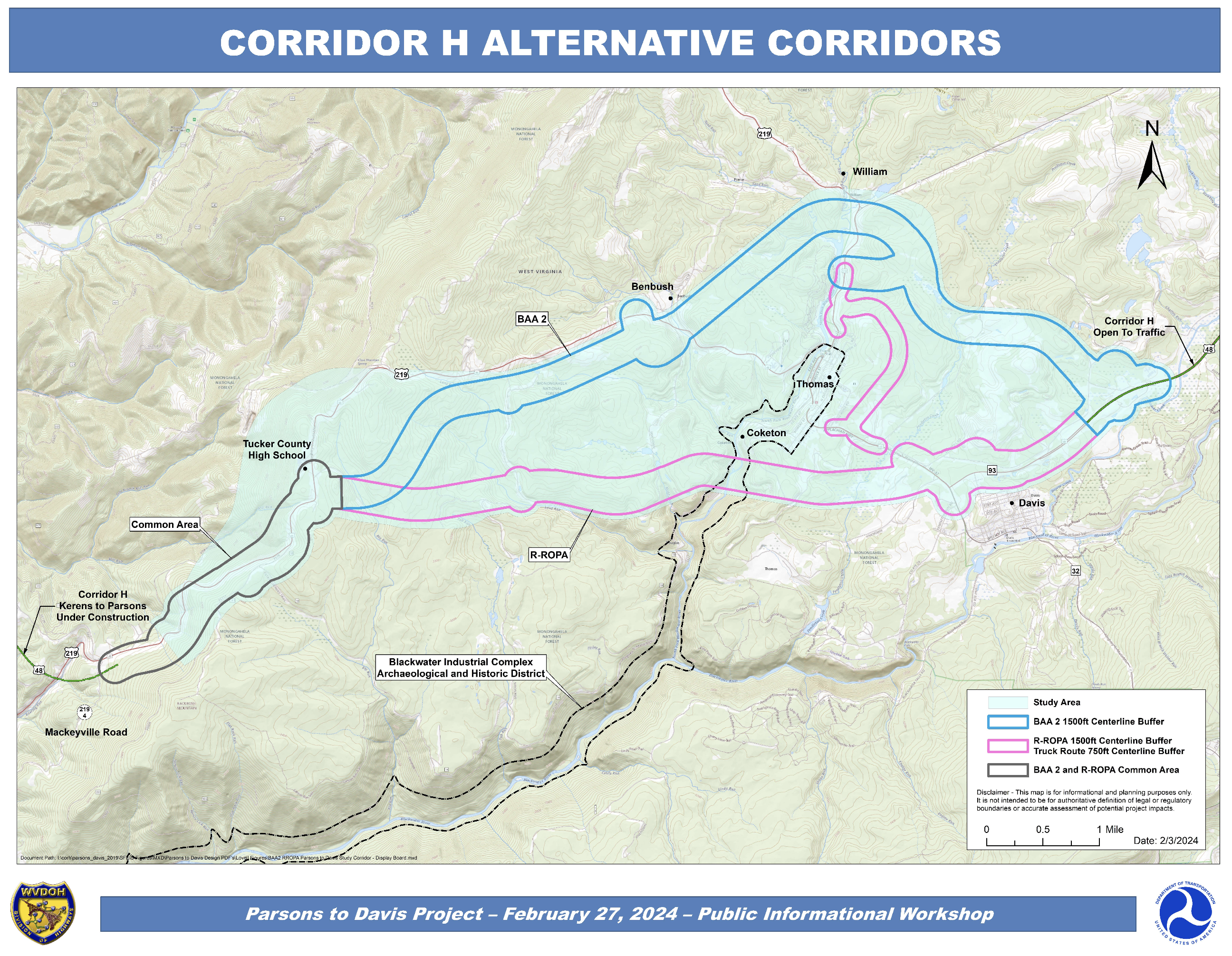
The old alignment that is constantly being changed is called the Refined-Revised Original Preferred Alternative (R-ROPA). Even after being tweaked again in 2023, R-ROPA is still outdated and threatens to split the towns of Davis and Thomas, create worse traffic flow issues, and require a bypass, which will completely surround Thomas with busy highways.
Impacts to towns, historic sites, Blackwater Falls State Park, National Forest, and major interstate and international trail routes still exist with the R-ROPA alignment. The highway would also impact major interstate and international trail routes at a higher rate if the R-ROPA alignment were to be constructed.
The short segment of WV Route 32 between Thomas and Davis will remain a “choke point” between the towns under R-ROPA. This continues to be a design flaw that funnels all north-south traffic travelling to and from Thomas and Route 219 north through this two-lane road.
Additionally, the Route 32 Truck Route/Thomas bypass—a feature unique to R-ROPA—will require all northbound traffic going into Thomas from Corridor H, Davis, and Canaan Valley to take an on-grade left turn across the high-speed truck route at either end of town.
With BAA2 there will be three separate exits for Davis, Thomas, and Benbush instead of just one under R-ROPA. This would give many alternative routes for traffic and not funnel all north-south traffic through a Route 32 “choke point” between the towns. It would also eliminate the need for a truck bypass.
What are the effects on recreational trails?
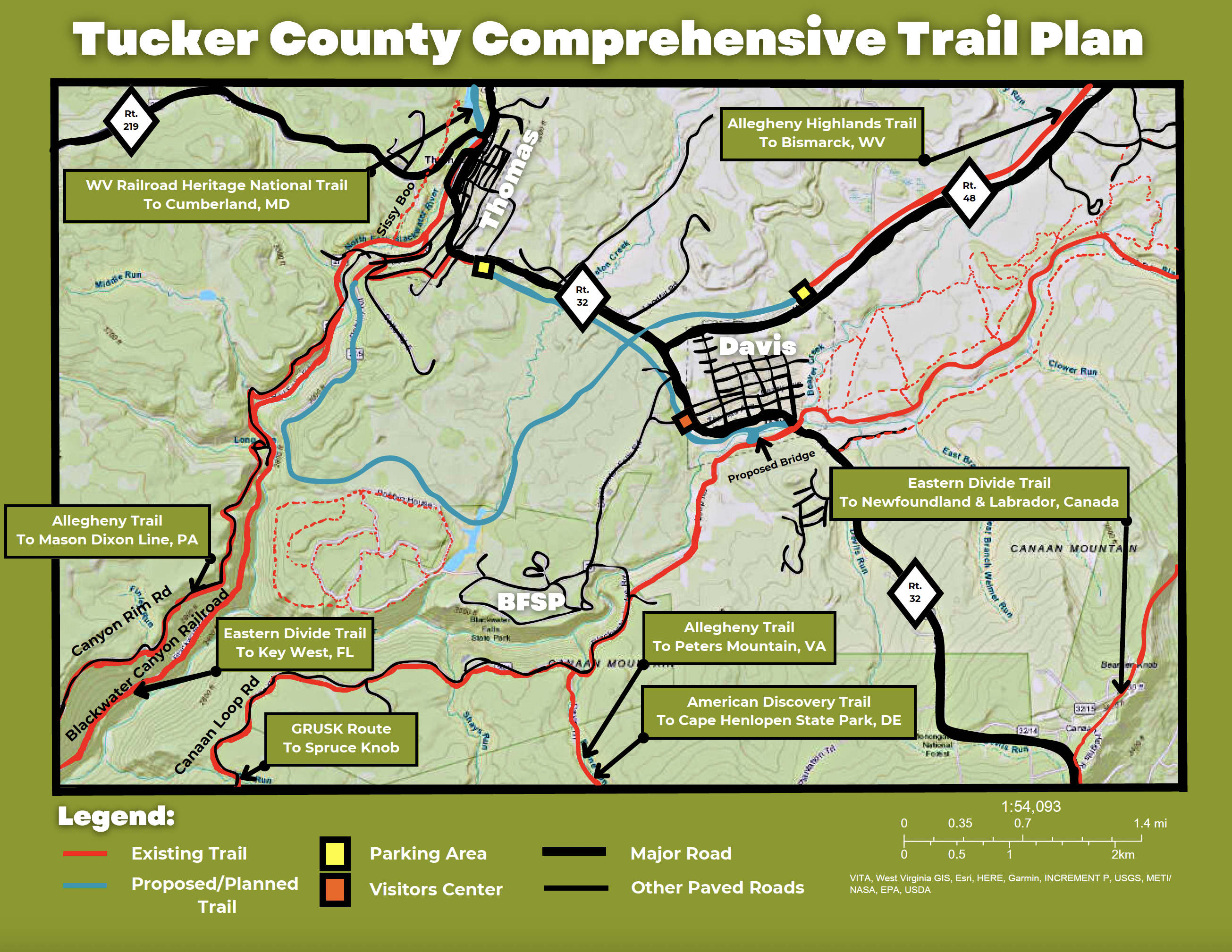
Currently, all traffic—including bicycles and pedestrians—between Canaan Valley, Davis and Corridor H going to and from Thomas are currently forced onto a busy narrow two-mile two-lane stretch of West Virginia Route 32. This situation would continue with R-ROPA regarding motor vehicle traffic flow.
The following trails are all currently routed on Route 32 between the towns of Thomas and Davis.
The 331-mile Allegheny Trail travels north-south on roads and hiking trails through West Virginia from the Mason Dixon Line near Bruceton Mills to the Virginia State line at Peters Mountain where it intersects the Appalachian Trail.
On the Allegheny Trail there are three trail crossings of Corridor H on the old R-ROPA route plan, and only one affected by the new BAA2 Northern route.
The Allegheny Highlands Trail (AHT), an old Western Maryland Railroad line, is split into two sections. One section is 35 miles from Thomas to Elkins, WV via the Blackwater Canyon railroad grade. The eastern section is open for 5.5 miles outside of Davis heading east toward the planned terminus at Bismarck, WV, 12 miles away.
Unfortunately, after years of being told this section of trail was going to be completed to Bismarck, the WVDOH has informed Tucker Countians that this section won’t be built. It was replaced with the shoulder of Corridor H which WVDOH engineers consider a Bike Route.
Another proposed section of the Allegheny Highlands Trail will link the two existing sections together via the Francis Grade between Davis and Thomas. This section appears as a trail on Western Pocahontas Property future development maps and would be an incredible addition to Tucker County’s rail-trail system.
Corridor H would cross the Allegheny Highlands Trail six times with the R-ROPA plan and only four with the BAA2 route.
The 5,057-mile long American Discovery Trail runs through Davis and Thomas coast to coast from Cape Henlopen, Delaware to Point Reyes, California. Four Corridor H crossings with R-ROPA, and only two with BAA2.
The 5,950-mile Eastern Divide Trail (EDT) runs north south from the eastern most point in North America at Cape Spear, Newfoundland, Canada to Key West, Florida. The EDT is the longest contiguous off road centric trail in the world with 68% unpaved and over 315,000 ft. elevation gain.
The Eastern Divide Trail would have three Corridor H crossings with R-ROPA and only one with BAA2.
The annual Gravel Race Up Spruce Knob (GRUSK) attracts hundreds of participants every July. There are two routes which utilize Route 32 between the towns. The 220- and 262-mile courses are run both multi-day and non-stop straight through which brings many riders onto Route 32 on a Friday night.
GRUSK would cross Corridor H twice with R-ROPA and none with BAA2. All of the above routes currently on Route 32 could all be routed off the road onto the trail between the towns endorsed by the Tucker County Commission.
Tucker County suggests a solution
Because of the many issues already caused by the funneling of all traffic between the towns, the Tucker County Commission recently unanimously adopted a Resolution to allow the West Virginia Division of Highways to build a separate pedestrian and bicycle trail paralleling Route 32 between Thomas and Davis.
This trail will enhance public safety, public health, community connection, traffic reduction, economic development and quality of life. Additionally, this trail will provide a separate pathway for four interstate and international trail routes.
The need for a multi-use trail between the towns is obvious. It’s a no brainer and a win-win for everyone. Tucker County Commissioner Fred Davis even called it the “Get the bikes off the road” resolution. Concern for public safety was a huge factor in the Commission adopting this resolution.
Politics get in the way
Despite all of the above, there is continued pressure from developers and powerful figures in the West Virginia government to keep the original outdated alignment of R-ROPA. There have been recent changes made to try to address some objections to the R-ROPA plan, but the big problems remain. The refinements and revisions are just lipstick on a pig.
But as recently as September 2023, Travis Long, the West Virginia Division of Highways engineer in charge of the Parsons to Davis section of Corridor H, indicated that the plan for this trail was only being considered in concert with the old, outdated R-ROPA alignment of Corridor H.
The possibility that the West Virginia Division of Highways is trying to use the planning for the construction of the bicycle/pedestrian trail as leverage for their outdated R-ROPA alignment is shameful. Even if BAA2 is constructed, traffic on Route 32 between the towns will only continue to increase, even without the long-haul truck component that exists now.
Pressure for choosing R-ROPA is possibly coming down from the landowner, Western Pocahontas Properties, who will be majorly impacted by the northern route. They may want to keep the old route to retain and promote their previous existing extensive planning.
Western Pocahontas’ plan includes a private/gated community adjacent to Blackwater Falls State Park, making the towns of Thomas and Davis into a “Smart City,” and building a major hospital project in Davis.
All of this pressure and planning originates from Charleston, Morgantown, Washington, D.C., and Austin, Texas (home of Western Pocahontas Properties). As a resident of Thomas, I can say none of these plans involved any of the locals I know of or their desired outcomes.
The bottom line
My fear is that the completion of Corridor H between Thomas and Davis is like the story of the idiotic death of The Goose That Laid the Golden Egg. R-ROPA is like the knife cutting open and forever dividing our two towns and degrading the small-town outdoor feeling and experiences for residents and visitors.
Two of the primary reasons for constructing the highway, besides being an east-west long-haul truck route, are to improve the local economy and the quality of life for our residents and visitors.
If Corridor H construction and R-ROPA alignment are going to divide our towns and degrade one of the premier natural areas in West Virginia, the State will fail to achieve the maximum resource potential of either of these lofty economic and quality of life objectives.
Matt Marcus is the manager of Blackwater Bikes in Davis and board member of the Blackwater Bikes Association.