Corridor H construction in Holly Meadows, West Virginia, in Dec. 2022.
By Hugh Rogers
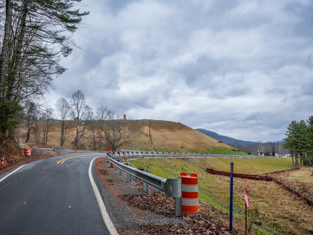
Since the partial settlement of a federal lawsuit allowed construction to resume on Corridor H, West Virginia’s Division of Highways (DOH) has spent its appropriations building west as far as Davis and east as far as Parsons. Meanwhile, as required by the agreement, it studied alternatives to fill the gap between. The main obstacle was the National Register of Historic Places-eligible Blackwater Industrial Complex (BIC) from Thomas south along the North Fork of the Blackwater River.
It has tossed aside those alternatives as not worth the cost of protection for the whole environment, physical, historical, recreational, and economic. Pushing ahead with its Original Preferred Alternative, slightly Revised (the ROPA), it faces objections from some of the same groups that sued in 1996. And more.
The settlement was only “partial” because both sides could opt out. If the DOH could convince a town council in either Thomas or Davis to accept the original route, it could proceed with planning in that direction. But if the ROPA does not comply with “any applicable law,” plaintiffs may sue again.
Also, groups or individuals who were not parties to that lawsuit are not bound by the settlement. Specifically, they can argue that the DOH must consider upgrading existing highways—the “improved roadway alternative”—for at least part of the Parsons-Davis project.
On September 12, the DOH hosted a “workshop” at Blackwater Falls State Park, the site of their announcement of the project’s “restart,” three years before. Comments were invited (again), and will be responded to in a Supplemental Environmental Impact Statement (SEIS). However, the most common reaction to the 2019 presentation, “Where are the alternatives to the ROPA?” got no answer in 2022. Instead, the DOH offered a few tweaks to its favored alignment.
Nevertheless, groups dedicated to environmental protection are nothing if not persistent. And comments do lay the groundwork for litigation, if necessary. Here are summaries of comments we submitted and some from organizations we admire.
WV Highlands Conservancy:
We were plaintiffs in the 1996 lawsuit and parties to the 2000 settlement agreement. In our opinion, the BIC is protected by federal law from intrusion by any federally-funded highway project. We think it should be protected for other reasons as well. As the DOH is required to update its EIS because the last one, more than fifteen years old, is “stale,” it must consider significant changes in the area’s socio-economic situation. A thriving tourism-based economy would be set back by a highway’s impacts on the BIC, the state park, the national forest, the trails, and the general character of the Thomas-Davis connection.
We know the completion of the Corridor from the east as far as Davis has helped to attract more visitors. Where it stops now brings people to the doorstep and doesn’t wreck the house.
We think it should offer an exit there for Davis and Canaan Valley, then veer west to an exit for Thomas and a bypass around the town. This Northern Route would keep trucks off Thomas’s main street—a major concern—while offering visitors direct access to its restaurants, shops and galleries.
Admitting that its ROPA would do nothing to divert trucks from Thomas, DOH added a “truck route” completely separate from the Corridor. It would cause new safety problems at its intersections. Putting the trucks back on Rt. 32 to access the Corridor, it would also be incompatible with Thomas’s city plan, which envisions a “greenway” between the towns.
Our Rivers Committee pointed out the ROPA’s threats to pristine mountain streams, especially considering the numerous violations of water pollution control regulations that have continued during construction of the next section west, Kerens to Parsons. Another issue, acid mine drainage (AMD), was raised by several commenters.
Friends of Blackwater:
Protecting the area they’re deeply involved with, FOB commented on the ROPA’s impacts to the historic district, as well as to trails they have already built and those they have gained funds to build.
They pointed to specific sources of AMD that would be exacerbated by the proposed alignment. For many years, FOB has worked with the Department of Environmental Protection (DEP) on a treatment facility that wasn’t designed to handle an increased flow. Other issues they raised included damage to public lands, and habitat for endangered species.
FOB said the northern route would avoid many of these concerns and obviate the need for a separate truck route. Finally, as they were not limited by the settlement agreement, they were free to urge the many advantages of a less destructive three-lane highway through the National Forest.
Corridor H Alternatives:
CHA, the lead plaintiff in our lawsuit, raised fundamental questions including the purpose and need for the road: Virginia has no plans to continue the Corridor from the state line to I-81, so it has lost its original purpose; traffic counts do not and will not justify such a large project. And they made the point about a revived economy that would be crippled, not encouraged, by the wrong alignment.
On water quality, CHA commented on downstream effects of sedimentation and AMD. It reminded DOH of the organization’s complaints about “gross underestimation” of excess waste (excavation) on other sections, and questioned recalculated estimates that supposedly reduced the cost of the ROPA by many millions.
CHA pointed to the difficult geology underlying the ROPA, both mountainside (the unstable Mauch Chunk formation) and mountaintop (the acid-producing Upper Freeport Seam, long mined for coal). And it disagreed with assurances that the ROPA would not affect Big Run Bog, a National Natural Landmark.
WV Rivers Coalition:
WVRC’s comments began with the “history of non-compliance with water pollution control permits,” focusing on the past five years on the Kerens to Parsons project. The list would have been much longer had they covered Bismarck to Davis (the assault on Beaver Creek) and all the sections before that. How could they not have serious concerns about potential impacts from construction on this even more difficult section?
The route from Parsons to Davis involves both high quality, Tier 3 streams and others much abused by mining. DOH claims that impacts to the former would be temporary. WVRC disagrees. Converting intact forest at the headwaters to a highway corridor, thus increasing temperature and altering hydrology, cannot help but permanently impair the streams’ water quality. That is exactly what is prohibited by our state antidegradation rule. With impressive restraint, the Coalition said, “It is not clear to us how this permanent degradation can be allowed . . .”
Turning from waters so pristine they may not be abused to waters so abused they must not be made worse, WVRC cited DEP records from the Abandoned Mine Lands program. The ROPA would cross several “problem areas” where pH has been measured below 4.0. Disturbing those areas with blasting and construction would cause additional water pollution.
The comments concluded with concerns about impacts to public use and enjoyment of “iconic” public lands.
Friends of the Cheat:
Where WVRC’s water quality concerns were largely based on evidence of DOH’s failures, FOC’s concerns arose from its special mission, and the inadequate assurances found in DOH’s earlier environmental documents. FOC has been working for 28 years to remediate the damage of AMD and improve water quality on the Cheat River. They do not want the gains that took so much effort to be undone by misplaced construction.
Based on that experience, FOC asked sharp questions: (1) What will the DOH do to avoid exposure of coal seams and acid drainage in the earliest design phase? (2) What water quality standards will DOH be held to if and when acid drainage is produced? Who will monitor its compliance? (3) How will DOH find the necessary space to treat acid drainage, given the constraints of the ROPA’s topography? (4) How will the necessary treatment be paid for? What sources of funding can be guaranteed after construction is finished?
They were not reassured by the overly casual plans for dealing with AMD found in previous EIS’s: postponing exploratory boring until the final design stage, and blithely declaring that their 1995 survey of AMD conditions between Buckhannon and Elkins told them what to expect for the rest of Corridor H. That’s simply not true. FOC offered examples from the DEP’s “problem areas” list also cited by WVRC. DEP monitoring has found that flows of polluted water from abandoned mines in the Thomas-Davis area averaged 10 times as much as Buckhannon-Elkins.
FOC knows from bitter experience the cost in money, time, and space to treat AMD adequately. From its position downstream, it fears the possible impacts of haste, ignorance and lack of care.
In conclusion, the Friends suggested a northern alternative is likely to produce less acid drainage—although it too would traverse the Upper Freeport coal seam. [Note: much of that would be encountered in the western section of Alternative 1D, which will have to be redesigned anyway.] They proposed geotechnical boring on both routes, comparison of expected acid drainage, determination of anticipated costs from each, and thus an informed choice. No matter how or where it will be built, they urge that first of all, adequate funding be secured for acid drainage treatment “into perpetuity.”
I would add that the comparison of alternatives suggested by Friends of the Cheat is no more than what NEPA requires of a thorough Environmental Impact Statement.