By Hugh Rogers
The words may be the same, but some old songs are changing. Consider the country hit, “I Forgot More Than You’ll Ever Know (About Her).” On records by Sonny James, Johnny Cash, Bob Dylan, and others, I used to hear the melancholy brag.
Now, what I hear is the “I forgot.”
On a less romantic subject, Corridor H, I have forgotten more than most readers would care to know. But help is on the way! A “story map” drawn up for the West Virginia Division of Highways (DOH) and the Federal Highway Administration (FHWA) by the DOH’s longtime consultant, Michael Baker International, is now online. Maps are just part of it; perhaps most important is the Document Library, beginning with the 1992 Corridor Selection Draft Environmental Impact Statement (a DEIS covering the entire corridor from Weston to I-81) and continuing up to the “Informational Workshop” held at Tucker County High School on Tuesday, February 27. Here’s the link.
And here’s where we are now: an official re-start for the Parsons-to-Davis project. Its formal announcement, the Notice of Intent to Prepare a Supplemental EIS for a Proposed Highway Project: Parsons to Davis, Tucker County, WV (the NOI), appeared in the Federal Register on February 6.
The new EIS is “supplemental” to a Final EIS published by the DOH in February 2007. That EIS did not result in a Record of Decision that would approve federal funding for construction; at that time, construction was proceeding westward from Wardensville to Davis, and there was no money available to resume building east of Elkins. The last approval of a preferred route for Parsons to Davis dated back to 1996, as part of the entire corridor. Too much has changed in the past 28 years, and even in the past 17, for it to avoid re-examination. And a bona fide EIS requires comparison of alternatives.
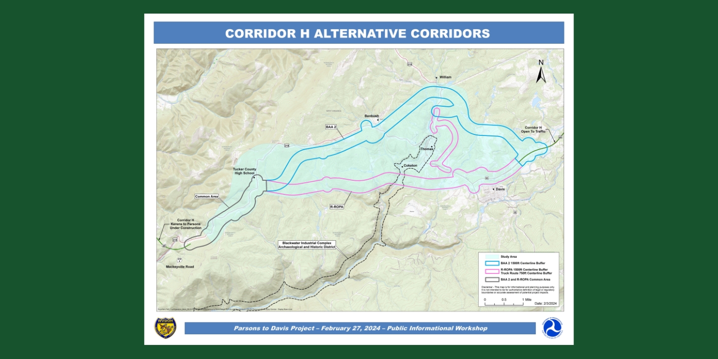
Obviously, the DOH didn’t want to go through that again. However, a large portion of the affected public has been calling for a better alternative to bypass Thomas to the north rather than cut between Thomas and Davis and avoid the Blackwater Canyon, the National Forest land there, and the Blackwater Historic District.
The first opportunity the public had to see revised plans for the project came at an “informational workshop” in August 2019. But there was only one option. Public dismay came through in written comments: 119 supported a northern alignment, two supported the Revised Original Preferred Alignment (ROPA). The agency responded: take it or leave it, we don’t have the time to consider any other route; those Go North folks really want to stop the project entirely. With more people paying attention, the next “informational workshop” in September 2022 drew more written comments: 355 for a northern route and 62 for ROPA.
A year later (see the September 2023 issue of the Voice), we learned that the Supplemental EIS would, after all, include a Blackwater Avoidance Alternative option. At the most recent “informational workshop,” it was clear that the DOH is still not happy about it. Jason Foster, the chief engineer on the project, told us, “You went to the feds, and the feds came to us and told us to re-examine the northern alignment. It’s your route.”
We hope he meant that in a general way. “Our route,” after all, is merely a sketch of how Alternative 1D from the first alignment selection process (2003-2004) could be adapted to avoid an enlarged landfill and the Thomas City Park and to merge with the ROPA before descending Backbone Mountain. You can see the sketch on the Allegheny-Blue Ridge Alliance website here.
What the DOH has shown so far looks like a literal translation of our sketch into a 1,500-foot-wide study corridor. Now, it’s called Blackwater Avoidance Alternative 2 (BAA2). If there’s not much room for difference on the north, given the landfill, the park, and the Thomas water supply, that is not true at all to the west. There could be many ways to complete the bypass and find a way down the mountain toward Parsons. Why use an exact copy of our cartoon?
The simple point we were making was that Alternative 1D’s western section was an unnecessary detour. It traversed steep terrain, crossed high-quality streams, required extra bridges, and lacked a convenient exit to the high school—for no good reason. When the DOH compared alternative 1D to their ROPA, most of its problems were on that extension. It looked as if it had been designed to fail.
We can’t let that happen now. In our comments on the NOI (due March 27 to www.regulations.gov/commenton/FHWA-2024-0007-0001), we call for an improved northern route. Only that will enable fair comparison, comply with environmental law, and result in a better project.
In recent years, the DOH has improved its Original Preferred Alignment to a Revised ROPA and now a refined ROPA. For example, it drastically reduced estimates of required earthmoving to make it comparable to Alternative 1D, while making no changes whatsoever to the latter. Now, it must play catch up. It isn’t locked into “our” study corridor.
Let’s make it the best possible Corridor H.